

First missThe weather forecast calls for nice for a week!
We decide to go to the West Arm for the first time with Elm’s boat for at least 3-4 days. The schedule is long.
We leave very early in the morning, 6 a.m., arriving after about three hours of sailing under an unfamiliar mountain bordering the Reid Glacier. Since there is no report of the ascent we choose the route seeing the mountain from below and from steep slopes, trying to avoid the dense vegetation, we reach the summit at 2 p.m.
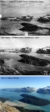
Thanks to the remains of an old wooden hut, we verify that King station, better known as Slip, from which A.J. Brabazon in 1894 took a photograph capturing the confluence of Glacier Bay’s two largest glaciers (Grand Pacific and Johns Hopkins), was located right on the summit at an elevation of 1200 m. The climb was very tiring we have very heavy backpacks with all the equipment, Elm, our captain, caught up in the excitement helps us and comes with us. He is not very accustomed to going to the mountains and in the steep places he is afraid. Done again the Brabazon shot and a 360° overview we make some shots and interviews for the documentary given the beautiful scenery.one on the West Arm of Glacier Bay
To descend we think it wiser to change our route and take some less steep valleys.
After a thousand vicissitudes and route changes we arrive on Reid beach in the late afternoon and with the boat we move to place our base camp that will remain fixed for three nights.
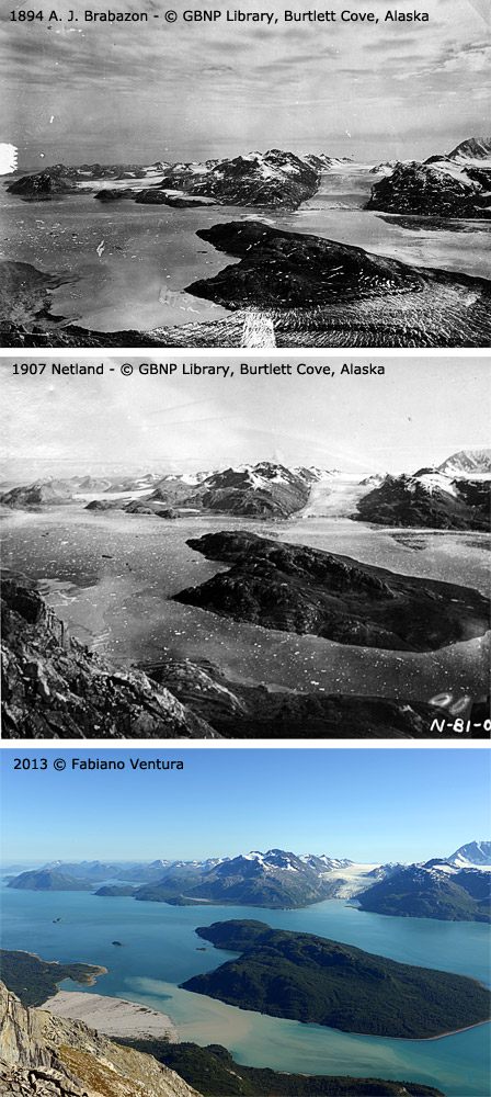
The next day with the boat we enter Tarr Fjord to find a way up the mountain from where Brabazon made a very aesthetic overview that highlighted very well the extent of the Great Pacific glacier reaching in 1894 almost touching the Johns Hopkins glacier.
We decide to try to ascend a very recessed creek but we are not sure if it will all be passable because we cannot see it all from below, it is possible that there may be rock jumps or snowfields that could obstruct our ascent route.
After passing several exposed and dangerous rock jumps we arrive on a snowfield and then, after a steep climb up some totally rotten and unstable rock channels after another 500 meters we reach a ridge that shortly brings us to the summit from where we discover that Brabazon had made his overview.
I immediately position my Linhof and repeat the 360-degree shots.
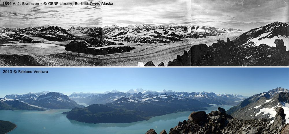
I also take the 1907 Reid image with Russell Island and we hurry down since it is now five o’clock in the afternoon and Elm would like to go home as early as this evening.
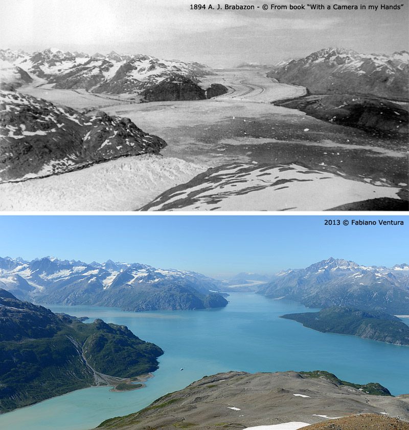
The next day we repeat an overview from two photos from Reid Station 1 by William O. Field taken in 1941 and then one by Brabazon from 1894 of the Reid front.
On the fourth day we have Elm pick us up and take us in front of the Reid front to repeat a shot of Reid station 4 and one of the Reid front from station 4.
In the afternoon roped up with crampons we ascend the glacier to do some monitoring and take some pictures of the huge very open crevasses on the forehead that will help us understand if this glacier, as hypothesized by our glaciologist Riccardo Scotti is in an advanced stage.
